 The above map provides an overview of the Marietta-area Trail System and its surroundings pre-2020.
Please note that new Broughton Trails have been added and some trails were renamed. SEE THE 2022 MAP BELOW LEFT.
Rudolph Farms trails shown below link the Marietta Trail System with our trails and the Devola Multi-Use Trail.
Download a two-page PDF of the entire Marietta, OH Trail System.
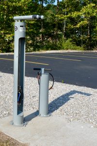
Bicycle repair stations are situated at the Devola Multi-Use Trail parking area on Route 821 and near the main entrance on the Southside of the picnic shelter near the bike rack.


Many Broughton trails can be found on AllTrails and the REI Hiking Project websites.
Our Orange Loop Trail was built by our local mountain biking club and is a must-ride in the Marietta area. See local and other MTB trails at the REI MTB Project website.
Use the AllTrails, Hiking Project and MTB Project apps to find your position on our trails.
Try OuterSpatial for detailed, seamless, personalized maps that adapt to your interests, highlighting nearby points of interest and curated routes for every adventure.
Learn about ticks, mosquitoes, snakes & more in this Washington Post article by Tara Parker-Pope.
* * * * * * * * * *
For your own safety, please plan to exit the Park before the trails close at dusk.
PLEASE NOTE THAT NO FIRES, ATVS (INCLUDING FOUR-WHEELERS), OR DIGGING ARE PERMITTED ANYWHERE IN THE PARK.